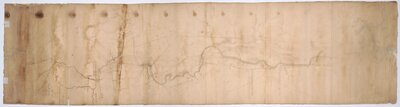
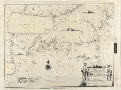
"This map describing the scituation [sic] of the several nations of Indians to the NW of South Carolina was coppyed [sic] from a draught drawn & painted on a deer skin by an Indian Cacique and presented to Francis Nicholson Esqr. Governor of South Carolina by whom it is most humbly dedicated to his Royal Highness George, Prince of Wales."
- "A map, sometimes known as the 'Catawba Deerskin Map', describing the situation of the several nations of the Indians to the north-west of South Carolina."--British Library.
- "A map, sometimes known as the 'Catawba Deerskin Map', describing the situation of the several nations of the Indians to the north-west of South Carolina."--British Library.
Cartographer:
From a draught drawn & painted on a deerskin by an Indian Cacique and presented to Francis Nicholson
Date:
1724
Attribution:
Retrieved from the Library of Congress, <www.loc.gov/item/2005625337/>.
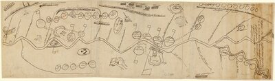
Manuscript maps of the Hudson Valley, land along Schoharie Creek, and the Seneca Country surrounding Seneca and Cayuga Lakes in what is now central New York. The Seneca Country map shows the location of Seneca villages at that time. Scale of the Hudson Valley map is 1:31,680; no scale given for the other two maps.
John R. Bleecker was a merchant, politican, and experienced surveyor and mapmaker in Albany.
"A map by Too Né in the Bibliothèque nationale de France captures some of the Arikara history that Clark left unrecorded. Drawn sometime in 1805 or early 1806, it shows the course of the Missouri River, Lewis and Clark in council at the Arikara and Mandan villages, the locations of more than thirty different Indian groups, and significant places in the history of the Arikara people."
Steinke, Christopher. “‘Here Is My Country’: Too Né’s Map of Lewis and Clark in the Great Plains.” The William and Mary Quarterly, vol. 71, no. 4, 2014, pp. 589–610. JSTOR, JSTOR, doi:10.5309/willmaryquar.71.4.0589
Cartographer:
Too Ne
Date:
1805 (or 1806)
Attribution:
Accessed from https://gallica.bnf.fr/ark:/12148/btv1b53006821k/f1.item.zoom
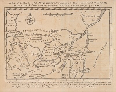
Title of Original map: A Mappe of Colonel Romers Voyage to Ye 5 Indian Nations: Going from New York to Albany Thence West ...
Reprint title used for the exhibit.
Originally drawn ca. 1700.
Oriented with north to the upper right.
Manuscript.
Photostatic copy.
Title in illustrative cartouche.
Includes ill.
"PSO/5285, K. top. CXXI 10."
Cartographer:
N/A
Date:
19? (reprint) 1700 (original)
Attribution:
Print map scanned from Olin Library Map Collection
![[Map of the several nations of Indians to the Northwest of South Carolina]. Catawba deerskin map](/images/3242/full/!400,400/0/default.jpg)
![[Maps of the Hudson Valley, Schoharie Creek and the Seneca Country]](/images/3243/full/!400,400/0/default.jpg)