Heezen and Tharp
Bruce Heezen and Marie Tharp produced a series of stunning topographic maps of the ocean floor between 1957 and 1977, while working at what is now the Lamont-Doherty Earth Observatory at Columbia University. Utilizing seismic data from earthquakes and naval echo-soundings (the latter severely restricted due to Cold War secrecy doctrines) Heezen constructed seismic profiles that Tharp - a peerless drafter with a unique talent for three-dimensional visualization - transformed into maps that clearly delineated the continental shelves and mid-ocean ridges for the first time. Their work would help pave the way for acceptance of the theory of continental drift.
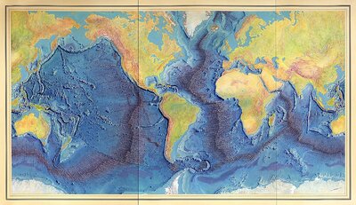
Painting of the Mid-Ocean Ridge with rift axis based on the scientific profiles of Marie Tharp and Bruce Heezen