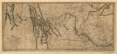
1. A map of Lewis and Clark’s track, across the western portion of North America from the Mississippi to the Pacific Ocean: by order of the executive of the United States Description: - Scale ca. 1:4,300,000. - Relief shown by hachures. - Meridian: London and Washington. - From Lewis, Meriwether, History of the expedition under the command of Captains Lewis and Clark, 1814. Cartographer: Lewis, Samuel Date: 1753 Attribution: Access from: https://loc.gov/item/79692907